


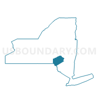
Voting District 010001, Delaware County, New York
About
Outline

Summary
| Unique Area Identifier | 626167 |
| Name | Voting District 010001 |
| County | Delaware County |
| State | New York |
| Area (square miles) | 52.93 |
| Land Area (square miles) | 52.78 |
| Water Area (square miles) | 0.15 |
| % of Land Area | 99.72 |
| % of Water Area | 0.28 |
| Latitude of the Internal Point | 42.17609430 |
| Longtitude of the Internal Point | -74.77473970 |
Maps


Graphs
Select a template below for downloading or customizing gragh for Voting District 010001, Delaware County, New York


Neighbors
Neighoring Voting District (by Name) Neighboring Voting District on the Map
- Voting District 010002, Delaware County, NY
- Voting District 020001, Delaware County, NY
- Voting District 030001, Delaware County, NY
- Voting District 050001 050003 050004, Delaware County, NY
- Voting District 080001, Delaware County, NY
- Voting District 140001-140007, Delaware County, NY
Top 10 Neighboring County Subdivision (by Population) Neighboring County Subdivision on the Map
- Delhi town, Delaware County, NY (5,117)
- Middletown town, Delaware County, NY (3,750)
- Colchester town, Delaware County, NY (2,077)
- Hamden town, Delaware County, NY (1,323)
- Andes town, Delaware County, NY (1,301)
- Bovina town, Delaware County, NY (633)
Top 10 Neighboring Place (by Population) Neighboring Place on the Map
Top 10 Neighboring Unified School District (by Population) Neighboring Unified School District on the Map
- Delhi Central School District, NY (8,147)
- Margaretville Central School District, NY (3,991)
- Downsville Central School District, NY (2,183)
- Andes Central School District, NY (1,206)
Top 10 Neighboring State Legislative District Lower Chamber (by Population) Neighboring State Legislative District Lower Chamber on the Map
Top 10 Neighboring State Legislative District Upper Chamber (by Population) Neighboring State Legislative District Upper Chamber on the Map
Top 10 Neighboring 111th Congressional District (by Population) Neighboring 111th Congressional District on the Map
Top 10 Neighboring Census Tract (by Population) Neighboring Census Tract on the Map
- Census Tract 9708, Delaware County, NY (3,762)
- Census Tract 9712, Delaware County, NY (3,750)
- Census Tract 9710, Delaware County, NY (2,900)
- Census Tract 9707, Delaware County, NY (2,624)
- Census Tract 9713, Delaware County, NY (2,077)